
Why in NEWS
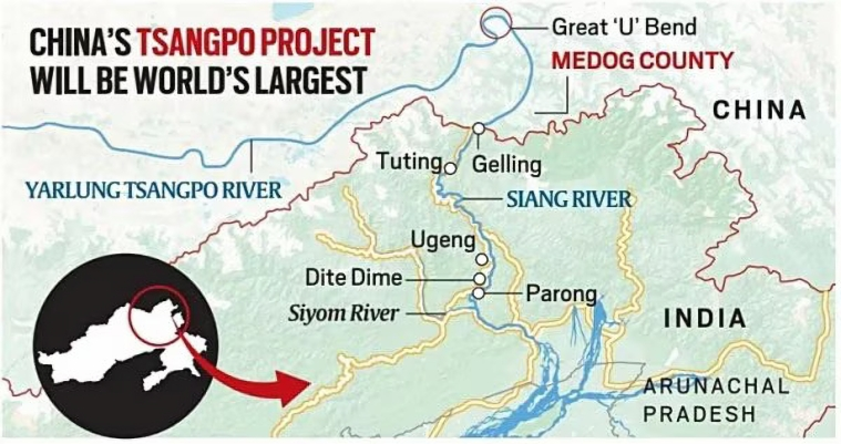
China is constructing a massive 60,000 MW hydropower project on the Yarlung Zangbo (Brahmaputra) River in Tibet, near Gelling, close to the Arunachal Pradesh border. It will be three times more powerful than the Three Gorges Dam and completed by the 2030s.
Key Terms and Concepts
| Term | Explanation |
|---|---|
| Yarlung Zangbo | The upper stream of the Brahmaputra River in Tibet, China |
| Cascade Dams | Series of dams built one after another on the same river to maximize hydropower |
| Seismic Zone | A region prone to earthquakes due to tectonic plate activity |
| Water Weaponisation | Using control over rivers to exert geopolitical or strategic pressure |
| Riparian Rights | Legal rights of a state over water flowing through or adjacent to its territory |
India’s Key Concerns over China’s Dam
| Concern | Details |
|---|---|
| Seismic & Ecological Risks | Himalayan fault line area is prone to earthquakes and flash floods; risk of massive displacement similar to the Three Gorges Dam |
| Water as a Weapon | China may release or withhold water to gain strategic leverage over India, especially during conflicts |
| Hydrological Disruption | Sudden flow changes may affect agriculture, fisheries, and ecosystems, especially in Siang Valley (Adi tribe region) |
| Traditional Knowledge Loss | Indigenous flood-control practices may become ineffective, leading to higher vulnerability |
| Legal and Diplomatic Vacuum | China is not part of any water-sharing treaty with India; unilateral decisions undermine India’s rights |
| Threat to Food & Energy Security | Reduced water flow may impact irrigation, flood regulation, and hydropower generation in Northeast India |
India’s Strategic Responses
| Response | Description |
|---|---|
| Siang Upper Multipurpose Project | India’s proposed 11.2 GW dam in Arunachal Pradesh to counter upstream Chinese control and manage floods |
| Monitoring Brahmaputra Flow | Although India has only 34% of basin area, it contributes over 80% of the river’s volume due to high rainfall and snowmelt |
| River Interlinking Plans | Proposed links like Manas–Sankosh–Teesta–Ganga and Jogighopa–Teesta–Farakka aim to balance water distribution and mitigate flood/drought risks |
| Diplomatic Engagements | Talks with China in 2025 focused on border tensions and river cooperation; confidence-building measures include resuming Mansarovar Yatra and tourist visas |
Measures India Must Take
| Measure | Details |
|---|---|
| Accelerate Hydropower Projects | Fast-track Upper Siang and expand basin-wide storage to absorb flow shocks from Chinese dams |
| Scientific Risk Assessment | Conduct ecological and strategic analysis of Chinese dam impact with real-time data modelling |
| Implement Interlinking Schemes | Operationalise NWDA’s plans to divert excess water to drought-prone areas and build inland channels for flood control |
| Strengthen Water Diplomacy | Renew Brahmaputra and Sutlej MoUs with China and build regional coordination with Bhutan, Bangladesh, and Myanmar |
| Disaster Preparedness Systems | Develop joint early warning systems and community resilience plans for flash floods and droughts |
Brahmaputra River System: Key Facts
Origin and Course
- Originates in Chemayungdung Glacier (Kailash Range, Tibet)
- Known as Yarlung Tsangpo in Tibet
- Enters India as Siang in Arunachal Pradesh
- Becomes Brahmaputra in Assam and Jamuna in Bangladesh
- Joins Ganga (Padma) and Meghna before draining into Bay of Bengal
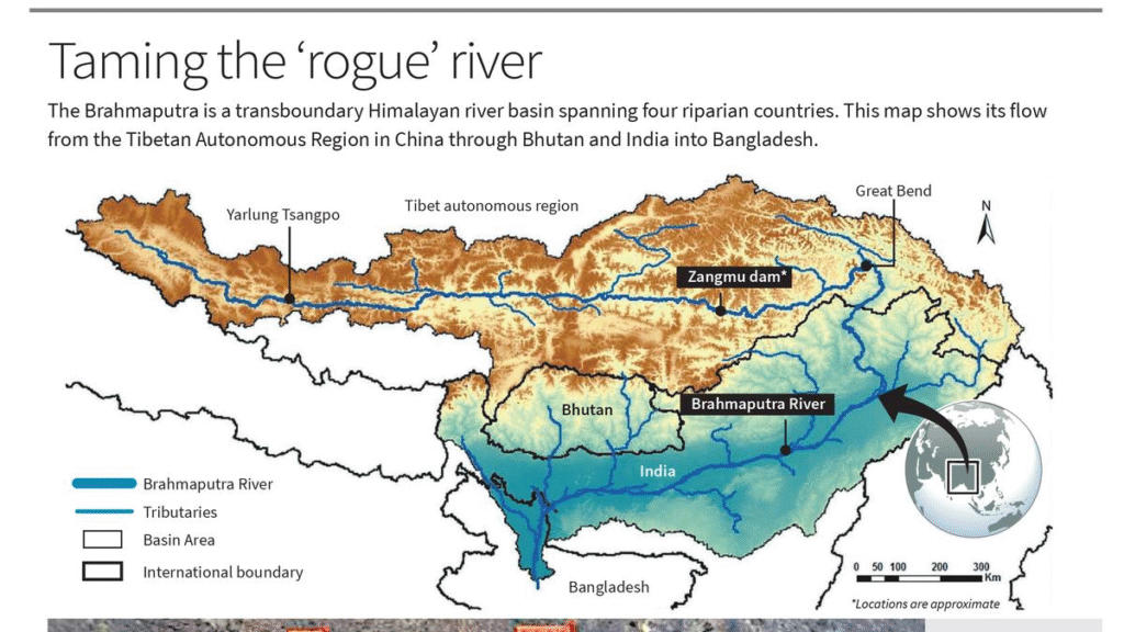
Basin Details
- Spans Tibet (China), Bhutan, India, Bangladesh
- Indian states: Arunachal Pradesh, Assam, West Bengal, Meghalaya, Nagaland, Sikkim
- Length: 2,900 km (916 km in India)
- Boundaries: Himalayas (north, west), Patkai Hills (east), Assam Hills (south)
Major Tributaries
- Right Bank: Lohit, Dibang, Subansiri, Jiabharali, Dhansiri, Manas, Torsa, Sankosh, Teesta
- Left Bank: Burhidihing, Desang, Dikhow, Dhansiri (south), Kopili
Ecological Significance
- 30% of India’s total water resources
- 41% of national hydropower potential
- Supports Kaziranga and Manas National Parks
- Home to Majuli (world’s largest river island) and Umananda (smallest)
In a Nutshell
Memory Code: DAM-PACT
D – Displacement risks from seismic activity
A – Adi tribal belt under threat
M – Majuli island & ecosystems at risk
P – Power play via water weaponisation
A – Arunachal projects counter China
C – China bypassing water treaties
T – Teesta and Ganga links as mitigation
Prelims Practice Questions
- The Brahmaputra River is called Yarlung Tsangpo in which of the following regions?
A. Bhutan
B. Tibet
C. Sikkim
D. Nepal - Which of the following Indian tributaries contributes significantly to Brahmaputra’s hydropower potential?
A. Ghaghara
B. Teesta
C. Gomti
D. Betwa - China’s Brahmaputra dam project poses risks to India because:
A. It will drain the river permanently
B. It may disrupt seasonal flow and cause floods
C. It prevents India from building dams
D. It is legally binding on India to support the project
Mains Practice Questions
- Discuss the strategic, ecological, and diplomatic implications of China’s mega-dam project on the Brahmaputra for India. (15 marks)
- How can India strengthen its hydropower and water security strategy to respond to transboundary water challenges posed by China? (15 marks)
Prelims Answer Key and Explanation
| Qn | Ans | Explanation |
|---|---|---|
| 1 | B | Yarlung Tsangpo is the name of the Brahmaputra in Tibet |
| 2 | B | Teesta is a right bank tributary with high hydropower potential |
| 3 | B | China’s dam can regulate water flow, causing floods or droughts downstream |